If you’re planning a trip to Istanbul in 2026, one of the smartest things you can do before you arrive is take a quick look at a good tourist map. After guiding travelers through the city for nearly twenty years, I’ve seen how much time and energy a clear map can save—especially on a first visit.
On this page, you’ll find free, easy-to-use PDF tourist maps of Istanbul covering the Old City (Sultanahmet), Beyoğlu (Taksim area), and the Asian Side. These are the most reliable maps, published by sources like Turkish Airlines, Istanbul Municipality, and Google, lightly annotated to help you spot major landmarks and understand how public transportation connects them.
Think of these maps as your big-picture planning tools for 2026—perfect for saving on your phone, using offline, or printing before you head out to explore.
🗺️ Istanbul Tourist Maps – Quick Guide (2026)
Want a simple, printable tourist map of Istanbul? Here’s a quick overview of what you’ll find on this page — and how to use these PDFs on the go.
📌 What You’ll Get: Free PDF tourist maps for the main sightseeing areas
🕌 Old City Focus: Sultanahmet / Historical Peninsula highlights
🚋 Also Covered: Beyoğlu (Taksim area) and the Asian Side
🧭 Best For: First-time visitors who want a clear, walkable plan
📱 How to Use: Save to your phone (offline) or print a copy before you head out
🧾 Tip: Use the PDFs as a big-picture guide, then zoom in on neighborhoods for details
📅 Last Updated: January 2026
Istanbul Tourist Map PDF 2026
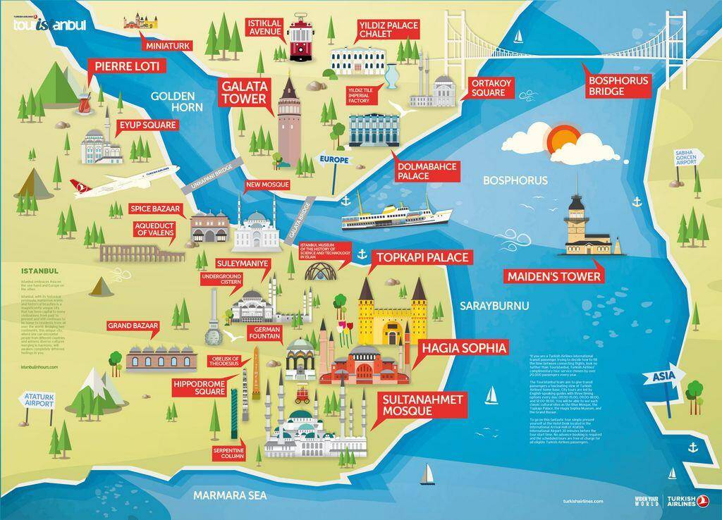
The colorful Istanbul tourist map above was published by Turkish Airlines a few years ago. On this map, we see the Historical Peninsula in the south and its most important historical monuments, Topkapi Palace, Hagia Sophia and the Blue Mosque (aka Sultanahmet Mosque).
However, when you expand the circle, you can see the Grand Bazaar and Suleymaniye Mosque located in the middle of the Historical Peninsula. In the following lines, I will also talk about the hidden gems of the Old City outside the tourist center.
The area to the north of the Golden Horn (beyond the Galata Bridge) is the relatively new part of the city and is known as “Beyoglu”. There are iconic historical monuments and streets here, such as Galata Tower, Istiklal Street and Taksim Square.
When you follow the shores of the Bosphorus, you can also see Dolmabahce Palace, located in the Besiktas district, and Ortakoy (at the foot of the Bosphorus Bridge), famous for its wonderful sea view.
Map of the Old City (Sultanahmet)
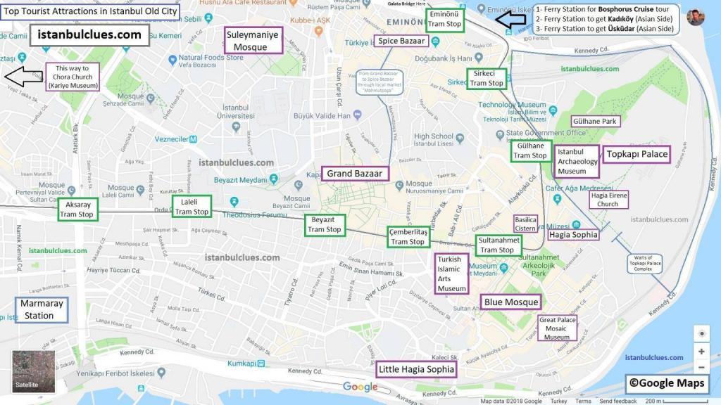
Istanbul old city map includes historical places in Sultanahmet and its surroundings. There are places here that are on everyone’s must-see list, and as can be seen on the map, it is possible to reach all of them with Tram T1 (line marked in green).
On this map, we can see some Byzantine structures that we missed in the introduction of the article. For example, the Little Hagia Sophia Mosque is actually a 6th-century Byzantine church named after Saints Sergius and Bacchus.
In addition, the Kariye Mosque (former Chora Church), located in the westernmost part of the Historic Peninsula, is a magnificent art showcase with the most beautiful mosaics from the Byzantine period.
Or, everyone knows the Grand Bazaar and Spice Bazaar, but very few people know Mahmutpasa Street, which lies between them and is surrounded by local markets. You can also see it marked on the map.
Map of Beyoglu (Taksim, Galata, Karakoy)
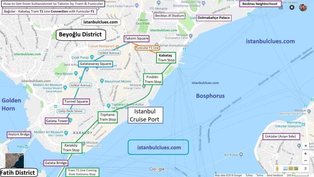
On the Beyoglu map, you can see districts such as Karakoy, Galata and Taksim, which are the rising stars of the city. Since the Istanbul Cruise Port (Galataport) is located here, rapid gentrification continues in these districts.
You can go to the north of the Golden Horn by taking the tram or walking over the Galata Bridge. Thus, you will leave Eminonu (where Spice Bazaar is) behind and you will now be in the relatively new part of the city.
As an Istanbulite, Karakoy is one of my favorite neighborhoods in the city. You can find everything about Istanbul’s famous street food in Karakoy, the traditional port district of Istanbul.
You can directly reach Istiklal Street, the most popular walking path of the city, from Karakoy with the Funicular F2 line. However, as a local, I would rather climb the slopes leading to the Galata Tower and explore the unique streets.
Around the Galata Tower, there are Nardis, the city’s most popular Jazz bar, 19th century buildings with the most beautiful AirBNB apartments, and souvenir shops offering creative designs.
While walking on Istiklal Street, you will see the Neo-Classical and Baroque apartment buildings that decorated Istanbul during the Westernization of the last period of the Ottoman Empire. Finally, you can reach Taksim Square, the heart of the city.
Frequently Asked Questions About Istanbul
This section answers the most common questions visitors have when using an Istanbul tourist map for trip planning. Whether you’re preparing your first visit or refining a detailed itinerary, these quick explanations will help you understand the city’s layout, transportation options, and the best ways to navigate its major attractions.
1. Where can I find the most accurate Istanbul tourist map?
The most reliable maps are produced by the Istanbul Metropolitan Municipality, Turkish Airlines, and Google Maps. In this article, I have gathered the versions that are clearest for first-time visitors and added small notes to highlight important landmarks and transportation lines.
2. Is the Istanbul tourist attractions map enough for planning a full-day itinerary?
Yes — the map shows the locations of major sights such as Hagia Sophia, Blue Mosque, Topkapi Palace, Basilica Cistern, Galata Tower, Istiklal Street, and Taksim. If you combine the map with Istanbul’s rail system (Metro, Tram, Marmaray), you can easily plan a full-day route without getting lost.
3. Do I need an offline map for Istanbul?
Google Maps works well in Istanbul, but downloading an offline version is always a good idea, especially inside the Historic Peninsula where mobile signal can fluctuate around old stone buildings. The PDF maps provided here are also ideal backups for offline use.
4. Which tram line goes to the main tourist attractions?
The Tram T1 line is the backbone of Istanbul’s sightseeing route. It connects Kabataş (near Dolmabahce Palace), Karaköy, Eminönü, Sultanahmet, and the Grand Bazaar area. This makes it the easiest way to reach nearly all major historical monuments without needing a taxi.
5. Does the Istanbul Airport connect directly to Sultanahmet or Taksim?
There is no direct tram or metro line to Sultanahmet, but the Havaist airport shuttle provides fast access to Taksim and Kadıköy (Asian Side). From Taksim, you can transfer to the Funicular + T1 Tram to reach Sultanahmet within minutes.
6. Is Istanbul walkable for tourists?
The Historic Peninsula (Sultanahmet–Sirkeci–Eminönü area) is extremely walkable. Most major attractions are within a few minutes of one another. However, areas like Galata, Karaköy, and Taksim have uphill sections, so checking elevation on the map helps when planning your route.
7. Which map should I use for the best navigation of Beyoğlu (Taksim–Galata) area?
Use the dedicated Beyoğlu District Map provided in this article (link above). It shows the narrow streets, uphill paths, and tram stations more clearly than general Istanbul maps.
8. Is public transportation easy to understand for first-time visitors?
Yes — Istanbul’s rail system is modern and easy to navigate. The maps here show how Metro, Tram, Metrobus, and Marmaray lines are distributed across the city. Once you understand how T1 and M2 lines work, most tourist routes become straightforward.
Conclusion

I hope these Istanbul tourist maps help you get a clearer picture of the city before you arrive. Istanbul is a huge, layered place, and having a simple map in your pocket—especially in 2026— can make your first days much smoother and more relaxed.
Of course, no single map can show everything. Beyond the famous landmarks, Istanbul is full of small streets, local neighborhoods, and hidden corners that you’ll naturally discover as you explore. Think of these maps as a starting point, not a checklist.
If you have any questions while planning your trip, feel free to leave a comment below. I check the comments regularly and usually reply within 48 hours.
And if you’d like to understand how all these places connect by metro, tram, and ferry, you may also want to check my guide to Istanbul’s public transportation maps. It includes the same maps in full resolution PDF format, along with simple explanations to help you move around the city with confidence.
Maps of Tourist Places in Istanbul by Serhat Engul
I am very impressed with your helpful hints. I’m not great at finding how to download etc., but have managed to print off three maps. The main map came out yellow and made the written signs unreadable, so I’ve had to go over them with a red pen.
Trying to copy and paste your written stuff but can’t.
I too am an ex tour escort (European tours, China and Albania), but now retired in Cyprus. Would be great to have a price for a three/four hour tour – thanks. Albeit I like to go off the beaten track myself, my ankle is in bad shape. We are two people.
Regards
Dear Carol Smart,
Thank you very much for your kind message — I’m really glad to hear that you found the article helpful.
I’m sorry to hear about the difficulty with the maps. Some printers don’t always handle the colors well, but I’m happy that you managed to make them usable.
It’s also lovely to hear that you worked as a tour escort — I’m sure you will enjoy Istanbul from a different perspective now.
I offer private half-day (3–4 hours) walking tours, and the pace can always be adjusted depending on your comfort level, with frequent breaks if needed.
You can find the details of my tours here:
https://istanbulclues.com/istanbul-guided-tours/
If you find a tour that interests you, feel free to contact me through the website, and I’ll be happy to get back to you with more details.
Kind regards,
Serhat Engül
Good day Serhat,
My name is Lawrence.
My wife, myself, and one other couple ( all mid 60’s) are coming to Istanbul in early September (I can confirm dates later).
Of course we want to SEE IT ALL, but only have a couple of days. We all enjoy history.
When you do your tours, are they mainly walking, or do you have a car/driver available?
If we are wanting to get into mosques, museums, etc, do you have any preferential status to get to the front of lines?
Our friends will be arriving on a cruise ship. We will be at an Air BnB.
What would be your ‘must see’ list. What are things that would be important to YOU, but not necessarily on the main tourist route?
And finally, what are your rates for 1/2, full day tours?
I look forward to your reply.
YThank you.
Dear Lawrence Setter,
Thank you for your interest in my tours. I prefer detailed correspondence via email.
I will answer your questions in detail via the email address you have noted in the system.
Kind regards,
Serhat Engul