If you’re visiting Istanbul in 2026, getting familiar with the metro map, tram, and ferry system before you arrive can make a huge difference. After guiding travelers around the city for nearly twenty years, I’ve seen how much easier Istanbul becomes once you understand how its public transportation fits together.
On this page, you’ll find an updated 2026 Istanbul Metro & Tram Map, along with the latest ferry routes, all available as free, full-resolution PDF files. These maps are ideal for offline use, whether you’re saving them on your phone or printing a copy before heading out.
If this is your first trip to Istanbul, moving between key areas like Sultanahmet (Old City), Beyoğlu (Taksim), Beşiktaş (Bosphorus), and Kadıköy (Asian Side) is something you’ll do almost every day. Below, I’ll show you how to travel between these districts efficiently using public transportation only—so you can explore the city comfortably without relying on taxis.
🚇 Istanbul Metro & Tram Map – Quick Guide (2026)
Trying to figure out how to move around Istanbul using public transportation? This quick guide shows what you’ll find on this page and how to use the metro and tram maps efficiently.
📌 What You’ll Get: Free PDF maps for metro, tram, Marmaray, and ferry lines
🚋 Main Focus: Istanbul Metro & Tram Map, updated for 2026
🌉 Also Covered: Marmaray, Metrobus, and Bosphorus ferry routes
🧭 Best For: First-time visitors navigating the city without taxis
📱 How to Use: Save the maps to your phone for offline access or print before your trip
🧾 Tip: Use the metro map for long distances, then switch to trams and ferries for sightseeing areas
📅 Last Updated: January 2026
Istanbul Public Transportation Map 2026
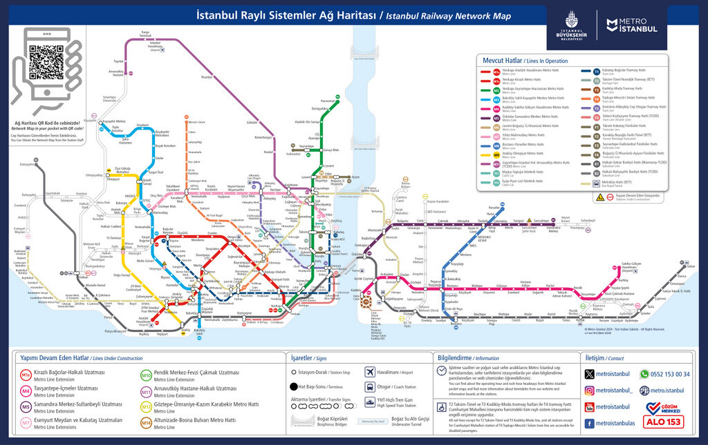
First of all, I want to introduce you to the most used public transportation vehicles in Istanbul. In the following lines, I will explain how you can use vehicles such as Tram, Metro, Marmaray, Metrobus and Ferry efficiently.
I uploaded the maps in low resolution so they wouldn’t slow down the page opening speed. However, you can immediately access the high resolution and printable PDF versions of these maps under the relevant headings. I hope it will be useful to you.
It’s strongly recommended to use public transport all the time if possible, as Istanbul’s traffic is one of the worst in the world during the rush hours. The busiest hours in Istanbul are between 7 and 10 in the morning and between 6 and 9 in the evening.
1. Istanbul Metro Map 2026
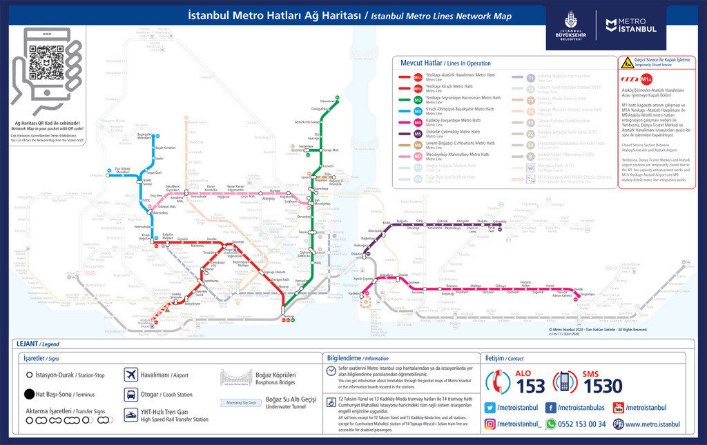
The most important destinations on the Istanbul Metro Map are Yenikapi, the public transportation hub of the Old City, Taksim Square, the heart of Modern Istanbul, and Kadikoy, the public transportation center of the Asian Side.
The metro line most used by tourists is the M2, which runs from the Old City to Taksim and beyond and covers business centers and large shopping malls, and is marked in dark green.
If you go to the Asian side of the city, the M4 line marked in pink will take you to Sabiha Gokcen Airport, the second airport of Istanbul. You can also reach the most popular shopping malls and hotels on the Asian Side via the M4 metro.
2. Istanbul Tram Map 2026
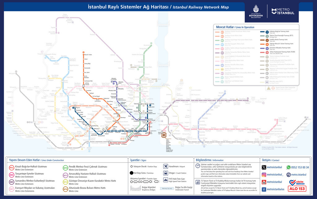
Istanbul Tram Map covers the most important tourist centers of the city. Especially Tram T1 is extremely efficient and handy to commute between the Old City (Sultanahmet, Sirkeci, Eminonu) and the Beyoglu (Karakoy, Galata, Taksim Square).
Major Tram Stops In the Old City
The major tram stations in the Old City cover the most important historical monuments that most tourists would like to see. Historical monuments can be reached on foot from tram stops in 10 minutes.
Beyazit (Grand Bazaar), Cemberlitas (Forum of Constantine), Sultanahmet (Blue Mosque and Hagia Sophia), Gulhane (Archaeological Museum), Sirkeci (Marmaray Train Station), Eminonu (Spice Bazaar).
After Eminonu, the tram crosses the Galata Bridge and thus you will cross the Golden Horn to the north side. The first stop in this relatively new district of the city will be Karakoy.
Major Tram Stops In the New City
Major tram stations in New City connect you to places like Galataport (Istanbul’s Cruise Port), Istanbul Museum of Modern Art, Galata Tower and Dolmabahce Palace. These stops are as follows, starting with the one closest to the Old City (and Galata Bridge):
Karakoy (Galata Tower), Tophane (Galataport Cruise Terminal), Findikli (Mimar Sinan University), Kabatas (Funicular Connection for Taksim Square).
Tram is enough for someone who will stay in Istanbul for a day or two. You can visit the most important sights by using the Tram T1 line. You can also walk to Dolmabahce Palace from Kabatas, the last stop of the tram.
3. Istanbul Marmaray Map 2026

Istanbul Marmaray Map that I shared above contains a yellow line. You can see that you can travel from one end of the city to the other with Marmaray by following this yellow line.
Marmaray allows you to travel quickly from the European side of Istanbul to the Asian side. You can cross the Bosphorus in 20-25 minutes by ferry, but in just a few minutes with Marmaray.
In this way, you can reach Uskudar in 4 minutes and Kadikoy in 8 minutes, which are the most popular spots on the Asian Side of Istanbul. I give these times according to Sirkeci Station in Istanbul Old City.
4. Istanbul Metrobus Map 2026
Istanbul Metrobus Map includes the districts that are on the outer edges of the city and are generally not very touristic. The brown line, starting from Sogutlucesme on the Asian Side and ending in Beylikduzu on the European side, represents the Metrobus line.
Roads that lead to Bosphorus Bridge (1st bridge) is always busy. The folk travelling from Asian Side to European Side had hard times passing through the bridge with a regular bus. Therefore Istanbul Metropolitan Municipality built some special lanes for the Metrobus and put comfortable buses into operation.
Metrobus travel all around Istanbul’s fringes. It provides a fast journey that saves you from traffic jams in Istanbul. However, Metrobus is packed with people during rush hours!
Although the metrobus line seems a bit confusing at first glance, Metrobus is often a necessary means of transportation. Because it’s very difficult to reach some congress centers and fairs of Istanbul without a metrobus.
5. Istanbul Ferry Map 2026
Istanbul Ferry Map shows us the locations of Istanbul’s nostalgic ferries and tour boats. These sea transport vehicles allow us to travel between the European and Asian sides as well as take a Bosphorus cruise.
For example, piers 1, 2 and 5 on the map show tour boats making a Bosphorus cruise. Pier 1 belongs to the Turyol Bosphorus boats. Pier 2 belongs to Sehir Hatlari‘s Bosphorus Cruise Ferries. Pier 5 belongs to Dentur Bosphorus boats departing from Kabatas. You can find more explanatory information for the Bosphorus cruise in this article.
Pier 3 symbolizes the ferries departing from Eminonu (Old City) to Uskudar and Kadikoy on the Asian side. There are actually two separate piers here, but I thought a single figure would be enough for both.
Pier 6 symbolizes the ferries departing from Besiktas to Kadikoy and Uskudar. Piers 7 and 8 are located in Uskudar and Kadikoy, two touristic districts of the Asian Side. Ferries depart from both to Besiktas and Eminonu.
What Is Istanbulkart?
Istanbulkart is a travel card valid for all public transportation vehicles listed in this article. It helps you save a great deal of money and time. It provides you some discount if it’s used multiple times within 2 hours.
The Istanbul Card charges 35.00 TL for the 1st ride. Whereas one use electronic ticket costs 50 TL. Istanbulkart also allows you to travel at a discount when you change vehicles on the same line. It charges on the 2nd time: 26.06 TL, 3rd time: 20.02 TL, 4th time: 13.02 TL (updated on January 1, 2026).
Tram T1, seen in the picture above, is the best friend of tourists visiting Istanbul. Because it provides transportation between the two most visited touristic spots, Sultanahmet and Taksim (with the funicular connection).
You can easily reach between Topkapi Palace and Dolmabahce Palace thanks to the tram. Normally these two palaces are far from each other. I would like to remind you that you can see the tram map of Istanbul in the first heading of the article.
Frequently Asked Questions About Istanbul
This quick FAQ section covers the most common questions travelers ask about using Istanbul’s metro, tram, ferry, and Metrobus systems. If you’re planning to explore the city without relying on taxis, these essentials will help you move smoothly between major tourist districts.
1. Which transportation card should I use in Istanbul?
You should use the Istanbulkart, which works on all public transport: metro, tram, ferry, Metrobus and buses. It also gives discounted transfers, making it the most economical option for travelers.
2. What is the easiest way to travel between Sultanahmet and Taksim?
The most tourist-friendly and stress-free route between Sultanahmet and Taksim is to take the T1 Tram from Sultanahmet to Kabataş, and then switch to the F1 Funicular from Kabataş to Taksim.
This route is popular for a reason: it’s fast, well-signposted, and easy to follow, even if it’s your first day in Istanbul. The tram takes you along the historic areas, while the funicular climbs quickly up to Taksim Square in just a couple of minutes.
You won’t need a taxi for this trip. Trams and funiculars run frequently throughout the day, and transfers at Kabataş are straightforward. It’s a reliable option that helps you avoid traffic and save time, especially during busy hours.
3. How can I go from the European Side to the Asian Side?
You can cross between continents via:
- Marmaray (fastest underground crossing),
- Public ferries (the most scenic option), or
- Metrobus (24/7, but more crowded and mostly used by locals).
4. Is it easy to get to the airport using metro lines?
Yes. Both of Istanbul’s airports are connected to the metro system, and getting there by public transportation is quite straightforward—especially if you are staying on the European side, where most visitors are based.
Istanbul Airport (IST) is served by the M11 Metro Line. If you are staying in central areas like Taksim or the Old City, you can first take the M2 Metro Line and transfer to the M11 at key interchange stations. This route is commonly used by travelers and works smoothly, even with luggage.
Sabiha Gökçen Airport (SAW), located on the Asian side, is connected via the M4 Metro Line. From the European side, the easiest way is to cross to Asia using the Marmaray line, then transfer to the M4. While this journey usually involves one or two transfers, the system is well-organized and clearly signed.
Overall, reaching either airport by metro is reliable, affordable, and much less stressful than dealing with traffic, especially during peak hours.
Conclusion
If you are preparing to visit Istanbul, the Istanbul Tourist Maps article on this site may be useful to you. In this second article, you can find the map above as a full resolution PDF file with detailed explanations.
As a footnote, I would like to point out that the Istanbul metro map (three of them) at the beginning of this article was prepared by the Istanbul Metropolitan Municipality. You can access the source of these maps from the PDF links I shared in the relevant lines above.
Istanbul Metro Map article (updated on January 1, 2026) by Serhat Engul
Thanks a lot Serhat!
Hi Mehran, you are welcome! Thank you for the feedback on the post. Cheers!